Day and Night Map FREE
Live map of where it is daytime, twilight or night time
INFORMATION
- Updated:
- BundleID:
- com.giudicelli.dayandnightmap
- Version:
- 1.1.0
- Category:
- Tools
- Required:
- Android
- Rating:
- Publish:
- 2018-03-14
- Price:
- Free
- Developer:
- Patrick Giudicelli
WHAT'S NEW
First Release
Day and Night Map FREE App SCREENSHOT
Day and Night Map FREE App DESCRIPTION
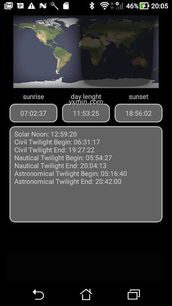
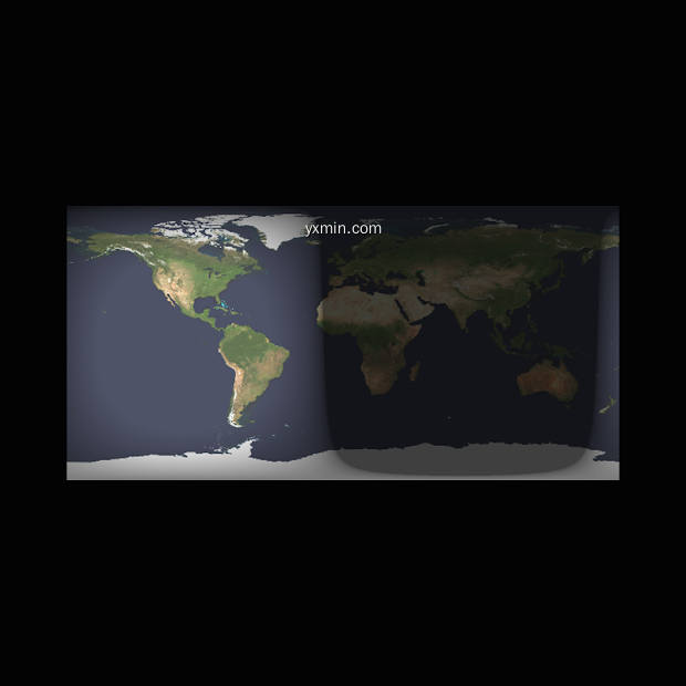
This app displays a world map that the regions of day light and night.
Features:
– Display sunrise and sunset.
– Display day lenght
– Display civil twilight begin and end
– Display nautical twilight begin and end
– Display astronomical twilight begin and end
SIMILAR to Day and Night Map FREE App
Calculates the traffic restriction zone
The application allows you to calculate a confinement area of 1km, 10km, 20km, 30km, 100km or 300km. around your GPS position. This allows you to respect and not to exceed the confinement area.Features:- Display the containment aera circle on a map.- Automatic calculation using GPS (No address to enter)- Sharing and saving the screenshot of the card- Possible choice between a 1km, 10km, 20km, 30km, 100km or 300km.
Allow you to send free of charge SMS to satellite phones.
This application allow you to send free of charge SMS to satellite phones. the following satellite phone providers: Iridium, Inmarsat,Thuraya.You simply have to enter the phone number of the recipient, your email address and the text of your message.Features:- Support 3 satellites providers: Iridium, Inmarsat, Thuraya- The recipient phone number is saved.- Your email address is saved

Essential travel info, maps and more about Canada
Canada GuideWithMe is an offline travel guide, which recommends detailed articles around the country in relation to your current location. Developed by travelers and for travelers, GuideWithMe is a rich source of general travel info as well as off the beaten track advice.Get around Canada guide, phrase lists, warnings how to stay safe and healthy, restaurants and hotel recommendations, local costs and taxes, road rules and a variety of other info are carefully stored in one app. And there’s more!Complete articles with multiple hotel and restaurant listings are suggested for Toronto, Ottawa, Montreal and other travel destinations.• USE OFFLINE. Save money on internet roaming fees and read articles even if you are offline and cellular data is not available.• DISCOVER ARTICLES RELATIVE TO YOUR LOCATION. Switch between country, region, city, travel topic articles recommended for your travel destination and current location. • VIEW ON THE MAP. GuideWithMe is based on map data, provided by MAPS.ME Canada, an offline maps app. An option to view the place on offline Canada map is offered.• CANADA CITIES. Toronto, Ottawa, Montreal, Vancouver, Calgary, Edmonton,..
Revolutionize your TLC and make it faster and easier with our dedicated app
Augmented reality for a greatly improved daily routine in lab life!In our capacity as experts for purification, we aim to offer maximum working comfort as well as highest efficiency in your laboratory, that is why the goal of these app is to support you and to save you time day by day. Therefore our App allows for:-Automatic detection of your compounds and calculation of your Rf and ΔCV (=ΔK) values-Direct (and secured) information transfer to puriFlash® purification system and more precisely to our AI ”Genius” included in our software, which suggests the best method for a successful purification-Data archiving, if desired.The app can be used extremely intuitively and user-friendly. It is divided in 3 main categories : - Flash & Go: « New TLC »1. Take a picture of your plate or download it via your library:The compounds are automatically detected. 2. Select the compounds of interest with just one click:The application calculates your Rf and ΔCV (=ΔK) values and indicates whether your Rf values are within a comfortable range for purification.From the smallest ΔCV obtained on your TLC plate,..
Based on WHO: Medical eligibility criteria for contraceptive use.
This App is intended for health-care providers.It contains recommendations intended to help health-care providers determine the safe use of contraceptive methods among women with various characteristics, habits and medical conditions.Providers can select conditions according to the patient, and the App assigns automatically a category for each method. Generally speaking and with medical criteria, categories 1 and 2 permit the use of a treatment in any case or with some considerations and categories 3 and 4 advise against or forbid its usage. For more information consult this App or its documentation.The recommendations refer to contraceptive methods being used for contraceptive purposes; the recommendations do not consider the use of contraceptive methods for treatment of medical conditions because the eligibility criteria in these cases may differ.The recommendations and all information contained in this App, are based on the document "Medical eligibility criteria for contraceptive use, Fourth edition 2009" published by WHO ("World Health Organization"). Adaptations and modifications to update its contents has been made following the conferences of the "Sociedad Española de Contracepción" (Spanish Society for Contraception) and the CDC document "U.S...

FLYCO Training Solution
FLYCO is the combined product of thousands of hours of aviation experience and know-how. Based in Istanbul, FLYCO's training solutions are prepared by seasoned veteran aviators, flight instructors and professionals. Along with this FLYCO uses advanced technological systems to streamline access, security and availability to pilots around the world.The system is available to airlines and corporate aviation companies from both the FLYCO web server or customized turnkey formats.FLYCO knows that training 'down-time' effects all commercial operators.The function of FLYCO is to reduce the need for dedicated claoom training and to offer flight and cabin crews a convenient way to maintain their ratings requirements.

SPORTident Orienteering is the app for your orienteering training.
SPORTident Orienteering is the Android app for managing your timed orienteering training. Read out cards and get splits printouts and rich online results instantly.FEATURES• Manage events, courses, entries, and results• Import courses and maps from OCAD• Import a competitor database to speed up registration• Read out SPORTident Cards with a connected BSM7 or BSM8 station• Fetch names and clubs from the SI-Card or the database• Auto-generate courses and classes based on punched controls• Auto-assign competitors to the best matching course after readout• Allow SI-Card reuse for multiple competitors• Print splits and rankings with the SPORTident Printer• Publish results to the web instantly• Visualise split times online with graphs and the novel spectromap• Share the results link on social media or print a QR code for easy access• Export results in CSV or IOF XML formats• The app is available and supports printing in Czech, Danish, English, French, German, Italian, Japanese, Portuguese, Russian, Simplified Chinese, Spanish, Swedish, and Turkish.REQUIREMENTS• A phone or tablet with USB OTG support• Android 5 or newer• A BSM7-USB or BSM8-USB station for reading out SPORTident Cards•..

Display the current weather
The weather station is an application for your android phone that give the current weather of your GPS position.Display:- Current weather with image- Pressure- Outdoor temperature- Humidity- WindYou can choose the unit system (celsius or fahrenheit)A internet connection is needed.
| Weather
Displays your location altitude
The digital altimeter uses the GPS and google map data server to display your altitude.Features:- Display the latitude and longitude- Display the GPS altitude- Display the Google map Altitude- you can choose between the metric nad imperial unit system
For Running or Biking
This application allow you to use your phone as a safety light for running or biking.Features:- Blinking red light- The speed of the light can be changed- A safety sound can be played.- The phone sleep function is disabled.- The application will not disturb the music player.

Live map of where it is daytime, twilight or night time
This app displays a world map that the regions of day light and night.Features:- Display sunrise and sunset.- Display day lenght- Display civil twilight begin and end- Display nautical twilight begin and end- Display astronomical twilight begin and end
| Tools
Search and find a wifi network name
This application allow you to search and find WIFI networks by using their name also known as SSID. Simply enter the WIFI SSID and push the find button. Once the SSID you have entered has been find your device will vibrate and display a popup text.
| Tools

Allow you to send free of charge SMS to satellite phones.
This application allow you to send free of charge SMS to satellite phones. the following satellite phone providers: Iridium, Inmarsat,Thuraya.You simply have to enter the phone number of the recipient, your email address and the text of your message.Features:- Support 3 satellites providers: Iridium, Inmarsat, Thuraya- The recipient phone number is saved.- Your email address is saved
| Tools

Display the barometric pressure from internet
This application the GPS to display the barometric pressure because your device do not have a barometric sensor the pressure is taken from the internet and the altitude is taken from the GPS.Features:- Display the barometric pressure from internet- Display the altitude from the GPSSettings Features:- The unit system can be chosen between the metric and imperial ones.
| Weather
This application allow you to use your telephone as a light meter
This application allow you to use your telephone as a light meter. A light meter is a device used to measure the amount of light. A light meter is often used to determine the proper exposure for a photograph.A Light meter is also used in illumination. His purpose is to measure the illumination level in the interior and to switch off or reduce the output level of luminaires.Features:- Display the current and maximum ammount of light level in LUX.- Display a graph of the current light level in LUX.- Display the recommended activity with the current light level.

Calculates the traffic restriction zone
The application allows you to calculate a confinement area of 1km, 10km, 20km, 30km, 100km or 300km. around your GPS position. This allows you to respect and not to exceed the confinement area.Features:- Display the containment aera circle on a map.- Automatic calculation using GPS (No address to enter)- Sharing and saving the screenshot of the card- Possible choice between a 1km, 10km, 20km, 30km, 100km or 300km.
| Tools

Teenager / youth / adolescent repellent using high frequency audio
The "teen tormentor" exploits young people's ability to hear very high frequencies, a power which declines once they reach their 20s.You can increase or decrease the frequency.13 frequencies between 8khz and 22 khz are available.The last frequency is memorized
| Tools